Vulture Conservation Workshop at Bhavanisagar
Date: May 5, 2012
Venue: RIRD Training Center, Bhavanisagar
Organisers: Arulagam and Care Earth
Target group: Vulture Watchers, Students and Nature lovers
Purpose: To strengthen the capability of vulture watchers and to spread awareness about Diclofenac threat to Vultures.
Medium: Presentations, personal interaction and printed materials.
Fund / Collaboration : CEPF
Kazhuguparvai - A Vulture Exhibition at Bannari
Date: April 5, 2012
Venue: Bannariamman Temple, Sathyamanglam Wildlife Sanctuary
Organisers: Arulagam and Care Earth
Target group: Visitors of Temple festival and Nature lovers
Purpose: To spread awareness about Vultures and treats due to Diclofenac drug and poisoning of carcass.
Medium: Exhibits, personal interaction and printed materials.
Fund / Collaboration : CEPF
Vulture Conservation Exhibition at Kangayam Cattle Show
Cattle Fair: Vellakoil Date: 19 January, 2012
Venue: Pushpagiri Nagar; Karur Road, Vellakoil
Organisers: Arulagam and Senaapathy Kangayam Cattle Research Foundation, Kuttapalayam.
Target group: Cattle Owners and NGO's
Purpose of Visit: To make contacts and awareness about impact of Diclofenac on Vultures.
Medium: Announcement through Loudspeakers and personal interaction.
Fund / Collaboration : CEPF
Survey on Diclofenac use for Cattle
Arulagam utilized the chance to conserve Vulture (Pinam Thinni Kalugu) with the support and guidance of Bombay Natural History Society (BNHS) and Royal Society for Protection of Birds (RSPB) through vulture advocacy program. About 99% of vulture population dramatically declined within the last two decades in India because of wide-spread usage of anti-inflammatory drug Diclofenac and Ketoprofan.
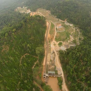
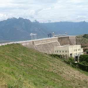
Hydroelectric Projects and their impact on the Landscape and River Moyar
Critical to the characterization process is the impact of Hydro-electric power projects in the Nilgiris, which have a distinct bearing not only on the river course and the river basin through dams and associated power houses, but also due to river course manipulation and the subsequent linkages that have been forged.
Pykara is one of the highest of south Indian streams originating in the Mukurti peak at an altitude of around 2400m ASL. It is the biggest stream in the Nilgiris Plateau. The stream flows over a number of cascades and waterfalls that it provides a drop of about 1000m before it reaches the Pykara Dam at Glenmorgan. Downstream, Pykara joins the River Moyar and eventually River Cauvery through its tributary, the River Bhavani.
The Pykara Hydroelectric Project Scheme was the first hydroelectric project that the state of Tamil Nadu (erstwhile Madras) launched and successfully implemented. The Project that was formally sanctioned during the British rule in 1929 was meant to generate and supply electricity for the industries in Coimbatore. Situated in the Nilgiris Plateau, the Pykara HP stands out as the highest in Asia and continue to be amongst the highest of hydroelectric projects in the world (source: Pell Frischmann Group and TNEB).
The Pykara Ultimate Stage Hydroelectric Project (PUSHEP) that was completed during the beginning of the 21st century was formally inaugurated in September 2005. The power generation capacity of PUSHEP is 150 MW.
Temporal and Spatial spread
The Pykara HP has been implemented in stages over a period of 75 years; PUSHEP being the final one. The spadework for the Project started in 1932. The first power-generating units were small with a capacity of 6.5 MW. Three such units were installed in the powerhouse located at Glenmorgan taking advantage of the run-of-river water alone. In order to enhance the available flow, two regulating storages were added.
These storages were located at Mukurti (upstream) and Pykara (downstream). The additional flow thus achieved enabled the installation of more power generation units. Subsequently, another storage dam was built across the Sandynallah stream. This reservoir was built to regulate and divert flows from a catchment of 44.03km² into the Pykara Dam. The network of reservoirs thus built helped achieve the set target of generating 70 MW of electricity.
In 1955, the Nilgiris Plateau experienced yet another major transformation due to the Kundah Hydroelectric Scheme. The Kundah HS led to the creation of Avalanche Dam (372m long; 57.66m high) and Emerald Dam (328.6m long; 65.72m high) around Portimund within the Kundah basin. A 733.77m long horseshoe-shaped tunnel that had the capacity to discharge 900 cusecs of water connected the two dams. The Avalanche and Emerald streams were tributaries that directly fed Pykara before the dams were constructed.Two other dams were constructed across the tributaries of Pykara in 1965; Parson’s Valley Dam (14.5km²) and Portimund Dam (10.6km²). These dams enhanced the volume of water that got diverted into the Kundah basin.
The Naduvattam Diversion Project completed in 1976 harnessed water from the 12.82km² Naduvattam basin that lies to the west of Pykara basin. In order to augment further the power generation capacity of the Pykara HP, water was diverted from the 12.95km² Lone Valley and Melkodmund stream in the Nilgiris Plateau; both streams flowed between Pykara and Sandynallah. The huge volume of water thus diverted into the Pykara Dam necessitated the enlargement of the fore bay. The enlargement of the Pykara fore bay was completed in 1978-79.
During the 1990s when the Pykara HP was in its final stage of implementation (PUSHEP) it had a well-established network of reservoirs that harnessed water from a catchment fed by Pykara, Sandynallah, Naduvattam, Melkodmund and Lone Valley streams (tributaries of River Moyar). The catchment has provided the gross storage necessary for making PUSHEP operational and generating the additional 150MW of electricity that was envisaged).
During 1946-52, the Moyar Hydroelectric Scheme was implemented. The Scheme was implemented using the tail water of the Pykara HP. The project is located at a distance of 16km downhill of the Pykara (Glenmorgan) power station. The Moyar HS also benefits by the water that is diverted from the Maravakandy Dam (located north-east of Masinagudi) through a flume channel. At Maravakandy there is a mini-hydroelectric scheme capable of producing 2.6 MW of power (Tyagi, 1995). The Maravakandy-Moyar flume channel is 6.81km long and 10.86m wide. The Moyar Ultimate Stage Hydroelectric Project (MUSHEP) that was proposed in 1995-1996 had envisaged the widening of the flume channel by another 2m. The channel that is around 2m deep had 19 bridges across it; 3 wide (5-11m), 16 narrow (1-5m) and 3 underground passages. The various hydroelectric projects that were implemented since 1932 in the Nilgiris Plateau together established a 53km network of tunnels (INO, 2007).
Building a Grassroots Constituency to Conserve the River Moyar in the Mysore-Nilgiri Corridor
Social Assessment to ensure compliance to CEPF Policy on Indigenous People
We proposed the project titled ‘Building a Grassroots Constituency to Conserve the River Moyar in the Mysore-Nilgiri Corridor on the premise that conservation programmes in the region have until date largely been perfunctory. We also found it ideal to propose a programme that takes a landscape approach rather be constrained by a politically or administratively defined unit, to ensure that the coverage is vast and uniform. The third and the most important factor that motivated us to propose this project is the fact that conservation research or programmes in the proposed project area have hitherto been very scarce in studying or involving human communities. It needs to be mentioned though that there have been a number of anthropological inquiries on the indigenous communities of the Nilgiris, largely during the Colonial period.
The proposed project design which takes the course of River Moyar as the deciding factor, covers at least five panchayats (decentralized grass root level planning and administrative units). This coverage though is not uniform. While the three panchayats viz Masinagudi, Mudumalai and Sholur would be most critical, the other two cover the fringe areas.
In-depth demographic studies of the three panchayats have not been carried out in the past; our preliminary assessment suggests that the landscape is home to the following broad categories of humans viz.
- Early settlers – largely during Pre-Colonial period who are now under the scheduled caste category of backward and most backward residing as homogenous units
- Recent settlers – mostly migrants in search of livelihoods
- Recent settlers – tribal communities – mostly communities in search of livelihood opportunities, landless labour and communities displaced from adjacent districts.
- Scheduled Tribes / Indigenous tribal communities – the original residents of the landscape, a number of endogamous groups. Notable for their involvement in the protection of the landscape. View themselves as custodians of the forest. Strong presence of customary rights and regulation in the use of natural resources. Notable are the Kurumbas (and their four sub-groups) and Irulars. Scheduled Tribes.
- The Scheduled Caste communities – considered the lowest in caste hierarchy. Not recognized by any past intervention in the landscape.
In view of the above, and also the past experience of working in other landscapes we propose the following:
The key outcome of the proposed project is the micro-plan, taking into consideration the following aspects:
- the project will not propose or create new jobs or provide dole in any form
- the project will recognize traditional and local institutions where indigenous and tribal communities are represented
- the project will ensure that no community is excluded because of their caste or tribal identity
- the project will ensure that marginal groups within the communities such as women are represented strongly.
- the project will attempt to understand and incorporate local cultural beliefs and norms for micro planning and will not seek to alter the same.
The project will be implemented only after consultations are held at the field level. These will be facilitated by the Gram sabha (an entity that is strictly voluntary and representative of all the communities) and the elected panchayat.
The proceedings of these consultations will be developed into mutual agreements.
The project will be jointly implemented with the Gram sabha and the panchayat. And as detailed in the proposal, it will be subjected to local review.
The Gram Sabha and the elected Panchayat for each community where the project will be implemented will function as a grievance mechanism for Indigenous People or other local communities who have any concerns or grievances about the project to raise them with the project team. In the unlikely event that a grievance is raised, Arulagam will ask the relevant Gram Sabha or Panchayat to convene a meeting between the project team and the affected parties, in order to resolve the conflict.
Arulagam will seek to hold these meetings within one month of any grievance being communicated to them. Any grievance raised will be communicated to CEPF, together with minutes from the meeting held to address them, plus a detailed plan of remedial action.
Long term sustainability of the project will be ensured will the project team working closely with the Gram Sabha and the Panchayat to develop proposals for the consideration of the State and Central Government, Other Non governmental organizations and Donor Agencies.
As a collaborative group of institutions striving to reconcile conservation and development goals, we appreciated the safeguards policy of CEPF and shall strive to adhere to all the issues/concerns and terms listed in the policy document.
Annotated List of Fishes Identified from the Bhavani-Moyar and Bhavani Sagar Riparian Ecosystem
S.No. |
Name of the Species |
Source of Information |
|||||
|---|---|---|---|---|---|---|---|
| Mukherji | Srinivasan & Ganesan | Rajan | Menon | Yazdani et al | CEPF Project | ||
| 1 | Amblypharyngodon melettinus | + | |||||
| 2 | Anguilla bengalensis* | + | + | + | |||
| 3 | Aorichthys aor | + | |||||
| 4 | Aorichthys seenghala | + | + | ||||
| 5 | Barbodes bovanicus | + | + | ||||
| 6 | Barbodes carnaticus | + | + | + | + | + | + |
| 7 | Barbodes jerdoni | + | + | + | |||
| 8 | Barbodes sarana | + | + | + | + | ||
| 9 | Barilius bendelisis | + | + | + | |||
| 10 | Barilius gatensis | + | + | + | + | + | |
| 11 | Catla catla | + | + | ||||
| 12 | Channa gachua | + | + | + | + | ||
| 13 | Channa marulius* | + | + | ||||
| 14 | Channa punctatus | + | + | ||||
| 15 | Channa striatus | + | |||||
Annotated List of Fishes Identified from the Bhavani-Moyar and Bhavani Sagar Riparian
Mukherji D D (1937) On a small collection of fish from the Bhavani river (S. India) BNHS35: 162-171 R Srinivasan and R Ganesan (1955) Contributions from the freshwater biological research station Bhavanisagar, Madras State No 1 Rajan, S (1955). Notes on a collection of fish from the headwaters of Bhavani river, south India. JBNHS 53: 44-48& Rajan, S (1963) Ecology of the fishes of rivers Pykara and Moyar (Nilgiris), S. India. Proc. Ind. Acad. Sci. 58 (B): 291-323 Menon, A G K (1999) Checklist –Freshwater Fishes of India, ZSI/Occasional Paper No 175 Yazdani, G M, Rema Devi, K, Raghunathan, M B and Singh, F D (2001) Fauna of Conservation Areas, Series 11: Fauna of Nilgiri Biosphere Reserve. Zoological Survey of India, pp207-224; this list is based on published information and 25 surveys in and around the Nilgiri Biosphere Reserve; only those specifically mentioned as Bhavani and/or Moyar Rivers are included. CEPF- Team: R J Ranjit Daniels, C Chenna Krishnan, N Muthu Karthick, K Ramasamy (Tracker), L Selvam (Fisherman), Kumar (Driver-cum-fisherman), Mahesh (Forest Guard), Das (Forest Watcher); Fish reported/seen during the field trip to Bhavani Sagar and Moyar River in February (8-11) 2011 and April (10-11) 2011
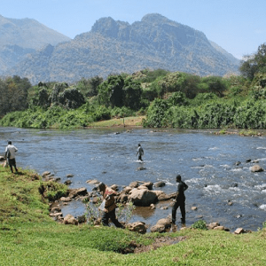
Indirect Sightings of Animals Recorded in River Transect Walk
S.No. |
Name of the Species |
Indirect Evidence |
Encounter Rate/km |
% Encounter Rate |
|---|---|---|---|---|
| 1 | Tiger (Panthera tigris) | 7 | 0.2 | 2.4 |
| 2 | Leopard (Panthera pardus) | 5 | 0.1 | 1.7 |
| 3 | Sloth Bear (Melursus ursinus) | 10 | 0.2 | 3.4 |
| 4 | Wild Dog or Dhole (Cuon alpinus) | 4 | 0.1 | 1.4 |
| 5 | Striped Hyena (Hyena hyena) | 2 | 0.0 | 0.7 |
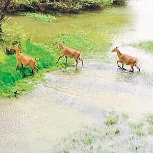
| 6 | Chital (Axis axis) | 70 | 1.5 | 23.8 |
| 7 | Sambar (Rusa unicolor) | 26 | 0.6 | 8.8 |
| 8 | Blackbuck (Antilope cervicapra) | 2 | 0.0 | 0.7 |
| 9 | Black-naped Hare (Lepus nigricollis) | 3 | 0.1 | 1.0 |
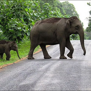
| 10 | Asiatic Elephant (Elephas maximus) | 101 | 2.2 | 34.4 |
| 11 | Gaur (Bos gaurus) | 5 | 0.1 | 1.7 |
| 12 | Feral Buffalo (Bubalus sp.) | 12 | 0.3 | 4.1 |
| 13 | Wild Pig (Sus scrofa) | 6 | 0.1 | 2.0 |
| 14 | Indian Porcupine (Hystrix indica) | 17 | 0.4 | 5.8 |
| 15 | Bonnet Macaque (Macaca radiata) | 3 | 0.1 | 1.0 |
| 16 | Oriental Small-clawed Otter (Aonyx cinerea) | 6 | 0.1 | 2.0 |
| 17 | Bengal Monitor Lizard (Varanus bengalensis) | 1 | 0 | 0.3 |
| 18 | Marsh Crocodile (Crocodylus palustris) | 14 | 0.3 | 4.8 |
Direct Sightings of Animals Recorded in River Transect Walk
S.No. |
Name of the Species |
# sightings |
# individuals |
Mean group size |
Encounter Rate/km |
|---|---|---|---|---|---|
| 1 | Chital (Axis axis) | 9 | 110 | 12.2 | 2.39 |
| 2 | Sambar (Rusa unicolor) | 3 | 6 | 2 | 0.13 |
| 3 | Blackbuck (Antilope cervicapra) | 3 | 6 | 2 | 0.13 |
| 4 | Asiatic elephant (Elephas maximus) | 3 | 11 | 3.7 | 0.24 |
| 5 | Gaur (Bos gaurus) | 3 | 8 | 2.7 | 0.17 |
| 6 | Feral Buffalo (Bubalus sp.) | 4 | 37 | 9.25 | 0.81 |
| 7 | Wildpig (Sus scrofa) | 2 | 3 | 1.5 | 0.07 |
| 8 | Bonnet Macaque (Macaca radiata) | 12 | 86 | 7.17 | 1.87 |
| 9 | Tufted Gray langur (Semnopithecus priam) | 13 | 159 | 12.23 | 3.46 |
| 10 | Indian Giant Squirrel (Ratufa indica) | 6 | 7 | 1.17 | 0.15 |
| 11 | Oriental small-clawed otter (Aonyx cinerea) | 1 | 2 | 2 | 0.04 |
| 12 | Bengal Monitor Lizard (Varanus bengalensis) | 3 | 3 | 1 | 0.07 |
| 13 | Marsh Crocodile (Crocodylus palustris) | 10 | 14 | 1.4 | 0.30 |
| 14 | Indian Rock Python (Python molurus molurus) | 1 | 1 | 1 | 0.02 |
Page 8 of 13