Hydroelectric Projects and their impact on the Landscape and River Moyar
Critical to the characterization process is the impact of Hydro-electric power projects in the Nilgiris, which have a distinct bearing not only on the river course and the river basin through dams and associated power houses, but also due to river course manipulation and the subsequent linkages that have been forged.
Pykara is one of the highest of south Indian streams originating in the Mukurti peak at an altitude of around 2400m ASL. It is the biggest stream in the Nilgiris Plateau. The stream flows over a number of cascades and waterfalls that it provides a drop of about 1000m before it reaches the Pykara Dam at Glenmorgan. Downstream, Pykara joins the River Moyar and eventually River Cauvery through its tributary, the River Bhavani.
The Pykara Hydroelectric Project Scheme was the first hydroelectric project that the state of Tamil Nadu (erstwhile Madras) launched and successfully implemented. The Project that was formally sanctioned during the British rule in 1929 was meant to generate and supply electricity for the industries in Coimbatore. Situated in the Nilgiris Plateau, the Pykara HP stands out as the highest in Asia and continue to be amongst the highest of hydroelectric projects in the world (source: Pell Frischmann Group and TNEB).
The Pykara Ultimate Stage Hydroelectric Project (PUSHEP) that was completed during the beginning of the 21st century was formally inaugurated in September 2005. The power generation capacity of PUSHEP is 150 MW.
Temporal and Spatial spread
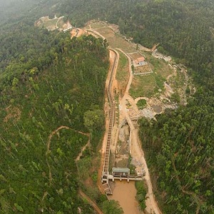
The Pykara HP has been implemented in stages over a period of 75 years; PUSHEP being the final one. The spadework for the Project started in 1932. The first power-generating units were small with a capacity of 6.5 MW. Three such units were installed in the powerhouse located at Glenmorgan taking advantage of the run-of-river water alone. In order to enhance the available flow, two regulating storages were added.
These storages were located at Mukurti (upstream) and Pykara (downstream). The additional flow thus achieved enabled the installation of more power generation units. Subsequently, another storage dam was built across the Sandynallah stream. This reservoir was built to regulate and divert flows from a catchment of 44.03km² into the Pykara Dam. The network of reservoirs thus built helped achieve the set target of generating 70 MW of electricity.
In 1955, the Nilgiris Plateau experienced yet another major transformation due to the Kundah Hydroelectric Scheme. The Kundah HS led to the creation of Avalanche Dam (372m long; 57.66m high) and Emerald Dam (328.6m long; 65.72m high) around Portimund within the Kundah basin. A 733.77m long horseshoe-shaped tunnel that had the capacity to discharge 900 cusecs of water connected the two dams. The Avalanche and Emerald streams were tributaries that directly fed Pykara before the dams were constructed.Two other dams were constructed across the tributaries of Pykara in 1965; Parson’s Valley Dam (14.5km²) and Portimund Dam (10.6km²). These dams enhanced the volume of water that got diverted into the Kundah basin.
The Naduvattam Diversion Project completed in 1976 harnessed water from the 12.82km² Naduvattam basin that lies to the west of Pykara basin. In order to augment further the power generation capacity of the Pykara HP, water was diverted from the 12.95km² Lone Valley and Melkodmund stream in the Nilgiris Plateau; both streams flowed between Pykara and Sandynallah. The huge volume of water thus diverted into the Pykara Dam necessitated the enlargement of the fore bay. The enlargement of the Pykara fore bay was completed in 1978-79.
During the 1990s when the Pykara HP was in its final stage of implementation (PUSHEP) it had a well-established network of reservoirs that harnessed water from a catchment fed by Pykara, Sandynallah, Naduvattam, Melkodmund and Lone Valley streams (tributaries of River Moyar). The catchment has provided the gross storage necessary for making PUSHEP operational and generating the additional 150MW of electricity that was envisaged).
During 1946-52, the Moyar Hydroelectric Scheme was implemented. The Scheme was implemented using the tail water of the Pykara HP. The project is located at a distance of 16km downhill of the Pykara (Glenmorgan) power station. The Moyar HS also benefits by the water that is diverted from the Maravakandy Dam (located north-east of Masinagudi) through a flume channel. At Maravakandy there is a mini-hydroelectric scheme capable of producing 2.6 MW of power (Tyagi, 1995). The Maravakandy-Moyar flume channel is 6.81km long and 10.86m wide. The Moyar Ultimate Stage Hydroelectric Project (MUSHEP) that was proposed in 1995-1996 had envisaged the widening of the flume channel by another 2m. The channel that is around 2m deep had 19 bridges across it; 3 wide (5-11m), 16 narrow (1-5m) and 3 underground passages. The various hydroelectric projects that were implemented since 1932 in the Nilgiris Plateau together established a 53km network of tunnels (INO, 2007).